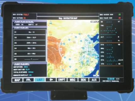
SDC-3 touch BDS multi-mode navigation system is used for airborne navigation. It has the functions of mobile electronic map, elevation rendering map, high altitude route map, flight management, waypoint management, satellite monitoring and ground proximity warning.
SDC-3 equipment has BDS / GPS receiver, which can continuously track BDS and GPS satellites in the air. It can measure the aircraft position, altitude and heading information at any place, at any time and in any environment, and display it on the electronic map. The electronic map can overlay various types of layers, including elevation rendering map, high altitude route map, near ground warning rendering map, etc., to display the situation information around the aircraft from multiple angles; After adding the flight plan, the equipment can carry out route navigation, airport takeoff and landing guidance and other auxiliary functions in real time.
The equipment is equipped with CAAC navigation database, with airports, navigation stations and waypoints; It can accommodate 1000 user-defined waypoints, store 50 flight plans, and support 50 waypoints for each flight route.
Product features
Using airborne embedded real-time operating system: as the core and foundation of airborne electronic equipment, the airborne operating system used by aircraft is a key product related to flight safety, and the technical index requirements and technical threshold are very high. Boeing and Airbus airborne equipment all use embedded real-time operating system, with high reliability, safety and real-time.
With dual satellite antenna receiving function, it is installed on both sides of the aircraft and receives satellite signals on both sides of the aircraft to ensure signal stability;
It has single BDS, single GPS and joint positioning mode;
It adopts high performance display and control platform, integrates satellite navigation, electronic map, flight management and auxiliary information query.
Multi function layer overlay: integrated navigation database layer, color terrain rendering map, near ground warning rendering map, high altitude route map and ground element layer to display navigation information in various ways;
A variety of terrain warning algorithms, real-time monitoring of the dangerous areas around and in front of the aircraft, as well as the dangerous situation of the vertical state of the aircraft;
90 second trend line, real-time display and prediction of future flight trajectory;
? Finger picking: click the screen to pick up the longitude and latitude, altitude and airport / navigation station / waypoint information of the specified position;
? Intelligent Flight Management: it supports segment guidance, direct flight and OBS guidance. The switching is flexible, convenient and intelligent, reducing the pilot's burden;
? SD card import route: external computer edits custom points and routes and loads them through SD card.
? Support Chinese operation interface, in line with the pilot's operation habits;
Support metric British system switching;
Touchscreen human-computer interaction, large font, large keyboard operation, intelligent input, convenient operation.
Technical parameters
Display computer parameters
Screen size: 10.1 inches;
Display resolution: 1280 (RGB) × 800;
Display brightness: 500CD / ㎡ (typ.);
Touch mode: 10 point capacitive touchscreen;
Power supply: 28vdc, power consumption less than 20W;
Installation: handheld or bracket installation;
Satellite receiver parameters
Positioning accuracy: horizontal ≤ 10m, elevation ≤ 10m (95%);
Speed measurement accuracy: ≤ 0.2m/s (95%);
TTFF: ≤ 90s;
Reacquisition time: no more than 5s;
Acquisition sensitivity: ≤ - 133dbm;
Tracking sensitivity: ≤ - 138dbm;
Short message communication frequency: ≤ 60s;
Number of short message receiving channels: 10;
First acquisition time of short message: ≤ 2s;
Reacquisition time of short message: ≤ 1s;
Dynamic performance: maximum speed: 340m / s, maximum acceleration: 4g.